
1811-5209/23/0019-0296$2.50 DOI: 10.2138/gselements.19.5.296
Keywords: Large igneous provinces; Franklin LIP; Sturtian glaciation; Snowball Earth; weatherability; sulfur aerosols; CO2.
INTRODUCTION
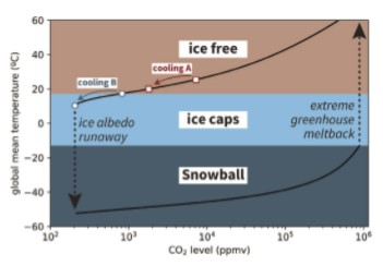
Snowball Earth glaciations are initiated once a critical threshold is reached for runaway ice-albedo feedback, where the growth of ice-sheets, which reflect rather than absorb solar radiation relative to land and ocean, leads to additional cooling and equatorward expansion of ice until it covers the globe (Pierrehumbert et al. 2011; Walker et al. 1981). Following an ice-albedo runaway, Earth can remain globally glaciated over a wide range of CO2 levels, resulting in a long-lived Snowball climate. This bifurcation of Earth’s climate system, where it can either be ice-free or in a Snowball at a given CO2 level, is a persistent feature of climate models of varying complexity (Fig. 1). Both the entrance to the Snowball state through ice-albedo runaway and exit through extreme greenhouse meltback are threshold problems in which the background paleogeography and climate sets the sensitivity to CO2 or albedo perturbations that can push the Earth to a new climate state (Fig. 1).
The geological record preserves evidence of the Snowball Earth climate bifurcation. Cryogenian (720–635 Ma) sedimentary rocks deposited under the influence of ice are present on every continent. Paleomagnetic data reveal that ice extended to the tropics twice during the Cryogenian Period and persisted for millions of years (Macdonald et al. 2010). Yet, it remains unknown what factors led to initiation of these Snowball Earth glaciations. A close temporal relationship between emplacement of the 719-Ma Franklin LIP (Fig. 2) and onset of the first Cryogenian Snowball Earth, the Sturtian glaciation, has suggested causal links (Macdonald et al. 2010; Macdonald and Wordsworth 2017; Pu et al. 2022; Dufour et al. 2023). Although LIPs are more commonly portrayed as drivers of global warming through the release of CO2, LIPs could also drive cooling towards a critical threshold due to two potential mechanisms: an albedo perturbation through eruption of sulfur aerosols (Macdonald and Wordsworth 2017), or an increase in global weatherability that draws down CO2 through increased efficiency of silicate weathering (Macdonald et al. 2010; Pu et al. 2022). The term “weatherability” refers to the cumulative factors that affect chemical weathering and associated CO2 sequestration aside from climate change, such as lithology, topography, and latitudinal distribution of continents and orogens. Continental flood basalts associated with LIPs have been hypothesized as an efficient sink for CO2, thereby increasing weatherability. Due to the relatively high concentrations of Ca and Mg in these rocks, they can sequester more carbon through carbonate precipitation in the ocean than typical crustal compositions (Dessert et al. 2001; Park et al. 2020b). Key to evaluating these potential mechanisms for cooling past a critical threshold are high-precision geochronological and paleomagnetic constraints, as both the albedo and weathering hypotheses make predictions for the timing of the Franklin LIP relative to onset of the Sturtian glaciation, and both albedo and chemical weathering are strongly dependent on latitude.
FRANKLIN LIP MAGMATISM
Lavas, sills, and dikes associated with the Franklin LIP span the Arctic margin of North America from the Yukon of NW Canada to the NW margin of Greenland (Fig. 2). The dikes form a radiating pattern and presumably fed large flood basalts across the region that have since been largely eroded, although the original surface extent is inherently uncertain. In a compilation of LIPs, Ernst et al. (2021) used the preserved record of intrusive rocks to estimate a Franklin LIP area of 2.6 Mkm2 (Fig. 2). If a polygon is extended to include additional recently identified Franklin LIP occurrences, the area increases to 3.1 Mkm2 (Fig. 2). Extending the area across the Arctic continental shelf to the inferred position of the plume head from radiating dikes leads to an area of 4.5 Mkm2, which would be larger still if the area further extended onto the interpreted conjugate continent of Siberia, as interpreted by Ernst et al. (2023). This area estimate exceeds the 3.5 Mkm2 estimate of the Siberian Traps, with the only LIPs interpreted to exceed the area of the Franklin LIP being the Central Atlantic Magmatic Province (CAMP) and the High Arctic LIP.
Preserved extrusive volcanic rocks directly associated with the Franklin LIP include the Natkusiak Formation basalt of the Minto Inlier, Victoria Island (Jefferson et al. 1985; Williamson et al. 2016) and the Kikiktat volcanics of Arctic Alaska (Cox et al. 2015). Other potential occurrences of Franklin LIP magmatism include rift-related rocks of the Mount Harper Volcanics in the Yukon and the Tatonduk Suite along the Yukon–Alaska border (Cox et al. 2018; Macdonald et al. 2018), and the Irkutsk Magmatic Province of Siberia (Ernst et al. 2023).
Natkusiak Formation, Victoria Island
The best exposures of the intrusive and extrusive relationships of Franklin LIP units are on Victoria Island, where the Shaler Supergroup culminates with the Natkusiak Formation (Jefferson et al. 1985). To the northeast, thinning of units below the Natkusiak Formation has been interpreted to record doming of the crust associated with a mantle plume (Rainbird 1993). The Natkusiak basalts are ~1100 m thick in northern exposures of the inlier (Jefferson et al. 1985) and only ~200 m thick in the south where the middle and upper members were eroded away below the sub-Cambrian unconformity (Williamson et al. 2016).
Co-magmatic diabase sills range from 1–100 m thick and show evidence for both fractional crystallization and crustal contamination, with olivine accumulation at their base and pegmatites and felsic enclaves in their upper levels (Heaman et al. 1992). Sills eviscerate the >4-km-thick Shaler Supergroup, which includes organic-rich shale and sulfate evaporites, and display extensive geochemical evidence for assimilation (Hayes et al. 2015). The shales and evaporites were hypothesized to be a source of sulfur for outsized aerosol production during LIP magmatism (Macdonald and Wordsworth 2017).
Kikiktat Volcanics, Arctic Alaska
The Kikiktat volcanics form a 10–1000-m-thick suite of lavas on the North Slope subterrane of Arctic Alaska (Cox et al. 2015). This allochthonous block was positioned against Arctic Canada during emplacement of the Franklin LIP, but its exact position along Laurentia’s northern margin remains uncertain (Macdonald et al. 2009). The Kikiktat volcanics are overlain by a poorly-sorted volcaniclastic sandstone with a dominant zircon population dated at 719.5 ± 0.2 Ma, which is interpreted to closely approximate the age of the underlying volcanics, and provides a strong tie with the Franklin LIP (Cox et al. 2015). Although the volcaniclastic unit does not record direct evidence for glaciation, it is overlain by Sturtian glacial deposits of the Hula Hula diamictite (Macdonald et al. 2009).

Mount Harper Volcanics and Tatonduk Suite, Yukon–Alaska Border
In the Ogilvie Mountains of the Yukon, the Mount Harper volcanics consist of >1000 m of basalt with minor rhyolite near the top (Macdonald et al. 2018). Sturtian-age glacial diamictite of the Eagle Creek Formation overlies the basaltic portion of the complex, but is not in contact with the rhyolite domes. Geochronology on the rhyolite domes and volcanic tuffs interbedded with the Eagle Creek Formation provide constraints on the onset of the Sturtian glaciation discussed below. Along the Alaska–Yukon border, ~50 km west of Mount Harper, the Tatonduk Suite includes dikes and ~330 m of pillowed and massive basalt flows and volcaniclastic breccia that are overlain by glacial deposits of the Rapitan Group (Cox et al. 2018). A N–S trending sub-vertical dike dated with U-Pb TIMS on baddeleyite at 713.7 ± 0.2 Ma (weighted mean 206Pb/238U age) was used to argue that the Tatonduk Suite post-dated the Mt. Harper Volcanics and was emplaced during, not before, the Sturtian glaciation (Cox et al. 2018). However, these data have large errors in the 207Pb/235U ratio and may more conservatively be interpreted to overlap in age with the Franklin LIP with an upper intercept date of 718.7 ± 16.5 Ma.
Irkutsk Magmatic Province, Siberia
Outside of North America, the Irkutsk LIP of southern Siberia has been correlated with the Franklin LIP and consists of gabbro complexes that have been dated between 730 and 710 Ma (Ernst et al. 2023). The radiating Sayan and Baikal dike swarms are interpreted as conjugate to the Franklin LIP radiating swarm in North America. Paleogeographic juxtaposition of the continents is consistent with existing paleomagnetic data, including the ca. 760-Ma Kitoi dikes paleomagnetic pole of Siberia (Evans et al. 2016).
RELATIVE TIMING OF FRANKLIN LIP AND ONSET OF STURTIAN GLACIATION
Timing of the Franklin LIP
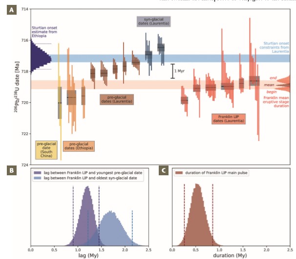
Published U-Pb zircon and baddeleyite ages from Franklin LIP rocks span ca. 730–710 Ma (Heaman et al. 1992; Macdonald and Wordsworth 2017). However, this spread may be attributed to complications with baddeleyite geochronology that can limit both precision and accuracy (Pu et al. 2022; Dufour et al. 2023). As a result, it is preferable to base interpretations of LIP duration and the relationship with glaciation on U-Pb zircon dates developed through chemical abrasion isotope dilution-thermal ionization mass spectrometry (CA-ID-TIMS).
Two recent studies have published new CA-ID-TIMS U-Pb zircon dates that provide more precise and accurate estimates of the timing and duration of Franklin LIP magmatism in both eastern and western Arctic Canada (Pu et al. 2022; Dufour et al. 2023). These dates are all between 720 and 718 Ma (Fig. 3). This interval is defined by a first pulse of low-volume and low-Ti Type-1 plume head magmatism (date of 719.86 ± 0.21 Ma) and more voluminous Type-2 magmatism (dates of 719.08 ± 0.22 Ma, 719.04 ± 0.19 Ma, 718.96 ± 0.19 Ma, 718.77 ± 0.30 Ma, 718.61 ± 0.30 Ma, 718.61 ± 0.30 Ma, and 718.33 ± 0.18; see Beard et al. (2018) for the definitions of types 1 and 2 magmatism). These dates and their uncertainties can be used to estimate a duration of the main stage of Franklin LIP activity of 540,000 years (95% range of 260,000 to 860,000 years), lasting from ca. 719.1 to 718.6 Ma.
Timing of Sturtian Glaciation Onset
In the Yukon, glacial deposits of the Eagle Creek Formation contain interbedded volcanic tuffs dated with U-Pb CA-IDTIMS zircon between 716.9 and 716.5 Ma and underlying rhyolite domes and flows between 718.1 and 717.4 Ma (Fig. 3; Macdonald et al. 2010, 2018). These dates have been interpreted to constrain the onset age of glaciation, postdating the youngest Mount Harper volcanics date of 717.43 ± 0.14 Ma (Macdonald et al. 2010), and pre-dating the oldest syn-glacial tuff date of 716.94 ± 0.24 Ma (Macdonald et al. 2018). This ca. 717-Ma age for Sturtian glacial onset is consistent with age constraints on glacial initiation from Ethiopia (MacLennan et al. 2018) and South China (Lan et al. 2020), such that it remains the most parsimonious interpretation for the data.
The emplacement age of the main phase of the Franklin LIP from ca. 719.1 to 718.6 Ma is therefore older than the onset of Sturtian glaciation between 717.4 ± 0.2 Ma and 716.9 ± 0.4 Ma. The time lag between the end of the main pulse of Franklin volcanism and the onset of the Sturtian Snowball Earth can be estimated by comparing the main pulse end dates with the youngest pre-glacial date, resulting in an estimated lag of 1.19 My (95% confidence range of 0.90 to 1.45 My), or by comparison with the oldest syn-glacial date, with an estimated lag of 1.69 Ma (95% range of 1.21 to 2.15 Ma; Fig. 3). Overall, these constraints indicate that there was approximately 1 to 2 million years between the largest pulse of Franklin LIP magmatism and the onset of low-latitude glaciation associated with the Sturtian Snowball Earth (Fig. 3).
PALEOMAGNETISM AND PALEOLATITUDE
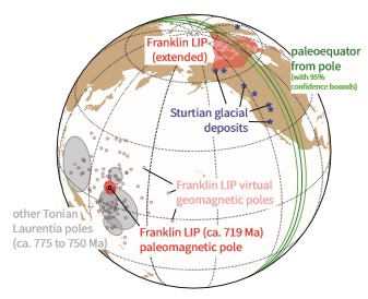
Paleomagnetic data from 83 intrusions associated with the Franklin LIP have been used to develop a mean paleomagnetic pole (Denyszyn et al. 2009), which shows that the Franklin LIP erupted in the tropics straddling the equator. On Earth today, land areas within 15° of latitude from the equator are the warmest and wettest places on Earth, and form the region known as the tropical rain belt (Park et al. 2020b). Given that enhanced precipitation in the tropics is the result of large-scale atmospheric circulation that arises on a differentially heated rotating Earth, it is reasonable to assume a similar distribution of climate belts at 719 Ma to those today. The Franklin paleomagnetic pole constrains ~95% of the LIP area to have been within 15° of the equator, and ~80% of the LIP was emplaced within 10° of the equator where it would have a high propensity to be warm and wet. Although climate sensitive sedimentary rocks indicate that the tropical rain belt was broadly associated with equatorial latitudes through the Phanerozoic, depending on regional circulation patterns, the arid belt can creep towards the equator given the high evaporative potential, which can be exacerbated in the interior of large continents. While there is evidence of arid conditions locally on Laurentia in the form of ca. 750-Ma evaporite deposits in northwestern Canada, the broad extent of the Franklin LIP within the tropical rain belt is consistent with much of it being in regions where precipitation exceeded evaporation (Fig. 4).
This Franklin LIP pole is a key constraint on Neoproterozoic paleogeography and is the youngest in a paleomagnetic pole path that comes from the ca. 777-Ma Gunbarrel LIP and the Chuar-Uinta Mountains-Pahrump basins that indicate a low-latitude position of Laurentia throughout the late Tonian Period (Fig. 4). While relatively low paleointensities of the geomagnetic field have been estimated from Franklin LIP units (Lloyd et al. 2021), the coherency of Laurentia’s pole path with a similar pole position obtained from Tonian rocks across the continent, as well as the consistency of virtual geomagnetic pole positions within the LIP itself, lend high-confidence to the pole. Together, these data are consistent with the geomagnetic field being stable and dipolar through the late Tonian (reinforced by strong paleointensity values ca. 750 Ma; Lloyd et al. 2021). In addition to constraining the Franklin LIP to have erupted in the tropics, the Franklin LIP pole also indicates that Sturtian glacial deposits were deposited near the equator (Fig. 4; Macdonald et al. 2010).
WEATHERABILITY AND SNOWBALL INITIATION
There are two hypotheses associated with the onset of ice-albedo runaway that could directly implicate the Franklin LIP: 1) a decline in CO2 levels through carbon cycle perturbations, and 2) a decrease in incoming solar radiation through the injection of sulfate aerosols into the stratosphere (Macdonald and Wordsworth 2017). The second hypothesis requires a close temporal linkage between the largest Franklin eruptions and the onset of the ice-albedo runaway that initiated Snowball Earth. The new geochronology displays a lag between the main phase of Franklin volcanism and Snowball onset, which appears inconsistent with the hypothesis that an albedo perturbation was the primary driver.
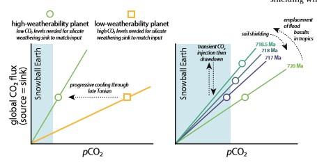
The more probable connection between the Franklin LIP and a carbon-cycle perturbation is that efficient chemical weathering of Ca- and Mg-rich basaltic rocks emplaced in the tropics may have lowered CO2 levels below the critical threshold for an ice-albedo runaway. Earth’s long-term climate is set by the sources and sinks of CO2. On millionyear timescales, the main source of CO2 is volcanism, while the main sink of CO2 is the chemical weathering of silicate rocks, ultimately leading to the formation of carbonate in the oceans. The climate dependence on chemical weathering provides a feedback that stabilizes CO2 levels and Earth’s climate state (Walker et al. 1981). In this framework, there are two principal ways to shift climate to a warmer or cooler equilibrium on geologic timescales: 1) a long-term change in CO2 outgassing rate; or 2) a change in the efficiency of CO2 sequestration through chemical weathering, that is, weatherability (Fig. 5).
Global weatherability during breakup of the supercontinent Rodinia may have been high due to an abundance of low-latitude continental margins in the tropical weathering belt. Having a concentration of land near the equator can also slightly decrease global temperature due to the increased reflectivity of land (higher albedo) relative to the sea (Eberhard et al. 2023). An additional factor associated with a low-latitude supercontinent is that as ice-sheets grow, they shield continents from both physical erosion and chemical weathering, resulting in reduced silicate weathering—a negative feedback (Marshall et al. 1988). This feedback is weakened with a low-latitude continental configuration. Weatherability can also change with distribution of high topographic relief, typically associated with active tectonics, between the warm and wet tropics and higher latitudes with less efficient weathering (Park et al. 2020a). Thus, a paleogeographic distribution of continents most sensitive to a runaway ice-albedo catastrophe is one with a maximum number of continental fragments (minimal continentality) distributed at low- and mid-latitudes, with no polar continents, and active collisions in the tropics (Eberhard et al. 2023). Geological data suggest that many of these features were achieved during the late Tonian and Cryogenian with the breakup of Rodinia followed by arc-continent collisions that likely occurred in the tropics (Park et al. 2020c). Within this paleogeographic context, enters the Franklin LIP.
Models and proxy data for pCO2 following LIP emplacement show that warming from the input of volcanic CO2 into the atmosphere will be counteracted by silicate weathering within ~1–2 My of emplacement, turning the LIP into a net CO2 sink (Dessert et al. 2001; Schaller et al. 2012). Subsequently, the development of regolith and soil shielding will mute the effects of a LIP on weatherability (Park et al. 2020b; Fig. 5). Coupled climateweathering models predict that the removal of recent flood basalt provinces on Earth today without any prescribed topographic change would change steady state pCO2 by >100 ppm (Park et al. 2020a), demonstrating the potential for cooling associated with the weatherability of LIPs.
CHALLENGES TO CAUSAL CONNECTIONS
A challenge to a causal relationship between the Franklin LIP and onset of Snowball Earth is that the second Cryogenian Snowball Earth event, the Marinoan glaciation, occurred <20 My after the end of the first Sturtian glaciation and does not appear to be associated with a LIP. This suggests that not all ice-albedo runaways are associated with LIPs and that Cryogenian paleogeographic boundary conditions were sufficient for another perturbation to initiate a second Snowball Earth.
Another challenge to the interpretation of a causal connection is that there are other similarly large LIPs emplaced at both equatorial and mid-latitudes that are not associated with glaciation, such as the CAMP and the Siberian Traps. However, both of these provinces formed when the Earth was warm and had a climate and paleogeography that was not sensitive to such a perturbation. Early-Jurassic climate records suggest cooling ~1 My after CAMP emplacement (Schaller et al. 2012), but as the weatherability increase associated with the LIP dissipated, the Earth stayed in an ice-free climate state (Fig. 5). Overall, there is a lack of correlation between LIPs and cooling trends throughout the Phanerozoic (Park et al. 2020b). Although LIP emplacement is not uniquely correlated with cooling, this result does not imply that LIPs are incapable of pushing the climate past the runaway ice-albedo catastrophe threshold in conjunction with other factors driving longer term cooling (Fig. 1).
The circumstances of the emplacement of the Franklin LIP were optimal for it to have an effect on climate. In addition to being the largest Neoproterozoic LIP preserved in the geological record and one of the largest in Earth history (Fig. 2), abundant high-quality paleomagnetic data from the province constrain it to have been emplaced in the tropics straddling the equator (Fig. 4). Emplacement in the tropical rain belt would have facilitated efficient chemical weathering, which could have been further enabled by a paleogeographic position near an open margin with tropical easterlies bringing moisture inland from the Asgaard Sea offshore of Greenland. The pulse of excess CO2 input from the LIP eruptions would have been drawn down through silicate weathering with the enhanced weatherability due to the LIP, leading to cooling beyond the initial climate state (Fig. 5). A cool climate has been suggested ~35 My prior to the onset of the Sturtian glaciation (MacLennan et al. 2020), but there are few constraints on the climate state for the intervening 35 My. If it turns out that the Earth was in a cool, partially glaciated climate state in the latest Tonian, then the Franklin may have been the LIP that broke the climate’s back.
ACKNOWLEDGMENTS
This work was supported by NSF FRES grants 1926001 and 1925990. We thank Robin Wordsworth, Dave Evans, Joshua Davies, Jean Bédard, and an anonymous reviewer for helpful suggestions. Code for the energy balance model shown in Figure 1 is available at https://doi.org/10.5281/ zenodo.10152708. Code and data for other figures are available at https://doi.org/10.5281/zenodo.10152921.
REFERENCES
Beard CD, Scoates JS, Weis D, Bédard JH, Dell’Oro TA (2018) Geochemistry and origin of the Neoproterozoic Natkusiak flood basalts and related Franklin sills, Victoria Island, Arctic Canada. Journal of Petrology 58: 2191-2220, doi: 10.1093/ petrology/egy004
Cox GM, Halverson GP, Denyszyn S, Foden J, Macdonald FA (2018) Cryogenian magmatism along the north-western margin of Laurentia: plume or rift? Precambrian Research 319: 144-157, doi: 10.1016/j. precamres.2017.09.025
Cox GM and 6 coauthors (2015) Kikiktat volcanics of Arctic Alaska—melting of harzburgitic mantle associated with the Franklin large igneous province. Lithosphere 7: 275-295, doi: 10.1130/ L435.1
Denyszyn SW, Halls HC, Davis DW, Evans DAD (2009) Paleomagnetism and U–Pb geochronology of Franklin dykes in High Arctic Canada and Greenland: a revised age and paleomagnetic pole for constraining block rotations in the Nares Strait region. Canadian Journal of Earth Sciences 46: 689-705, doi: 10.1139/E09-042
Dessert C and 6 coauthors (2001) Erosion of Deccan Traps determined by river geochemistry: impact on the global climate and the 87Sr/86Sr ratio of seawater. Earth and Planetary Science Letters 188: 459-474, doi: 10.1016/S0012-821X(01)00317-X
Dufour F and 5 coauthors (2023) New U–Pb CA-ID TIMS zircon ages implicate the Franklin LIP as the proximal trigger for the Sturtian Snowball Earth event. Earth and Planetary Science Letters 618: 118259, doi: 10.1016/j.epsl.2023.118259
Eberhard J and 5 coauthors (2023) Sensitivity of Neoproterozoic Snowball-Earth inceptions to continental configuration, orbital geometry, and volcanism. Climate of the Past 19: 2203-2235, doi: 10.5194/ cp-19-2203-2023
Ernst RE and 6 coauthors (2023) Identification of the ca. 720 Ma Irkutsk LIP and its plume centre in southern Siberia: the initiation of Laurentia–Siberia separation. Precambrian Research 394: 107111, doi: 10.1016/j.precamres.2023.107111
Ernst RE and 8 coauthors (2021) Large igneous province record through time and implications for secular environmental changes and geological time‐scale boundaries. In: Ernst RE, Dickson AJ, Bekker A (eds) Large Igneous Provinces: A Driver of Global Environmental and Biotic Changes, Volume 255 (First Edition). American Geophysical Union, John Wiley and Sons Inc, Washington DC, pp 1-26, doi: 10.1002/9781119507444.ch1
Evans DA, Veselovsky RV, Petrov PY, Shatsillo AV, Pavlov VE (2016) Paleomagnetism of Mesoproterozoic margins of the Anabar Shield: a hypothesized billion-year partnership of Siberia and northern Laurentia. Precambrian Research 281: 639-655, doi: 10.1016/j. precamres.2016.06.017
Hayes B and 6 coauthors (2015) Sulfide immiscibility induced by wall-rock assimilation in a falut-guided basaltic feeder system, Franklin large igneous province, Victoria Island (Arctic Canada). Economic Geology 110: 1697-1717, doi: 10.2113/ econgeo.110.7.1697
Heaman LM, LeCheminant AN, Rainbird RH (1992) Nature and timing of Franklin igneous events, Canada: implications for a Late Proterozoic mantle plume and the break-up of Laurentia. Earth and Planetary Science Letters 109: 117-131, doi: 10.1016/0012-821X(92)90078-A
Jefferson C, Nelson W, Kirkham R, Reedman J, Scoates R (1985) Geology and copper occurrences of the Natkusiak basalts, Victoria Island, District of Franklin. Geological Survey of Canada Current Research 85-1A: 203-214, doi: 10.4095/120045
Lan Z and 6 coauthors (2020) Toward refining the onset age of Sturtian glaciation in South China. Precambrian Research 338: 105555, doi: 10.1016/j. precamres.2019.105555
Lloyd SJ, Biggin AJ, Halls H, Hill MJ (2021) First palaeointensity data from the cryogenian and their potential implications for inner core nucleation age. Geophysical Journal International 226: 66-77, doi: 10.1093/gji/ggab090
Macdonald FA, Wordsworth R (2017) Initiation of Snowball Earth with volcanic sulfur aerosol emissions. Geophysical Research Letters 44: 1938-1946, doi: 10.1002/2016GL072335
Macdonald FA, McClelland WC, Schrag DP, Macdonald WP (2009) Neoproterozoic glaciation on a carbonate platform margin in Arctic Alaska and the origin of the North Slope subterrane. Geological Society of America Bulletin 121: 448-473, doi: 10.1130/B26401.1
Macdonald FA and 8 coauthors (2018) Cryogenian of Yukon. Precambrian Research 319: 114-143, doi: 10.1016/j. precamres.2017.08.015
Macdonald FA and 9 coauthors (2010) Calibrating the Cryogenian. Science 327: 1241-1243, doi: 10.1126/science.1183325
MacLennan SA and 7 coauthors (2020) Geologic evidence for an icehouse Earth before the Sturtian global glaciation. Science Advances 6: eaay6647, doi: 10.1126/sciadv.aay6647
MacLennan SA and 9 coauthors (2018) The arc of the Snowball: U–Pb dates constrain the Islay anomaly and the initiation of the Sturtian glaciation. Geology 46: 539-542, doi: 10.1130/G40171.1
Marshall H, Walker JC, Kuhn WR (1988) Long-term climate change and the geochemical cycle of carbon. Journal of Geophysical Research 93: 791-801, doi: 10.1029/jd093id01p00791
Park Y, Swanson-Hysell N, Macdonald F, Lisiecki L (2020a) Evaluating the relationship between the area and latitude of large igneous provinces and Earth’s long-term climate state. In: Ernst RE, Dickson AJ, Bekker A (eds) Large Igneous Provinces: A Driver of Global Environmental and Biotic Changes, Volume 255 (First Edition). American Geophysical Union, John Wiley and Sons Inc, Washington DC, pp 153-168, doi: 10.1002/9781119507444.ch7
Park Y and 5 coauthors (2020b) Emergence of the Southeast Asian islands as a driver for Neogene cooling. Proceedings of the National Academy of Sciences 117: 2531925326, doi: 10.1073/pnas.2011033117
Park Y and 9 coauthors (2020c) The lead-up to the Sturtian Snowball Earth: Neoproterozoic chemostratigraphy timecalibrated by the Tambien Group of Ethiopia. Geological Society of America Bulletin 132: 1119-1149, doi: 10.1130/ B35178.1
Pierrehumbert R, Abbot D, Voigt A, Koll D (2011) Climate of the Neoproterozoic. Annual Review of Earth and Planetary Sciences 39: 417-460, doi: 10.1146/ annurev-earth-040809-152447
Pu JP and 9 coauthors (2022) Emplacement of the Franklin large igneous province and initiation of Snowball Earth. Science Advances 8: eadc9430, doi: 10.1126/sciadv. adc9430
Rainbird RH (1993) The sedimentary record of mantle plume uplift preceding eruption of the Neoproterozoic Natkusiak flood basalt. The Journal of Geology 101: 305-318
Schaller MF, Wright JD, Kent DV, Olsen PE (2012) Rapid emplacement of the Central Atlantic Magmatic Province as a net sink for CO2. Earth and Planetary Science Letters 323-324: 27-39, doi: 10.1016/j. epsl.2011.12.028
Walker JCG, Hays PB, Kasting JF (1981) A negative feedback mechanism for the long-term stabilization of Earth’s surface temperature. Geophysical Research Letters 86: 9776-9782, doi: 10.1029/ JC086iC10p09776
Williamson N, Ootes L, Rainbird RH, Bedard JH, Cousens B (2016) Initiation and early evolution of the Franklin magmatic event preserved in the 720 Ma Natkusiak Formation, Victoria Island, Canadian Arctic. Bulletin of Volcanology 78: 19, doi: 10.1007/s00445-016-1012-9